When North Becomes South: The Great Survey Disaster of 1889
Somewhere in rural Indiana stands a perfectly functional bridge that connects two places nobody ever intended to connect. Built with federal funds and constructed to exacting engineering standards, the Millbrook Bridge represents one of the most expensive directional errors in American infrastructure history. The fact that people still drive across it daily makes the story even more remarkable.
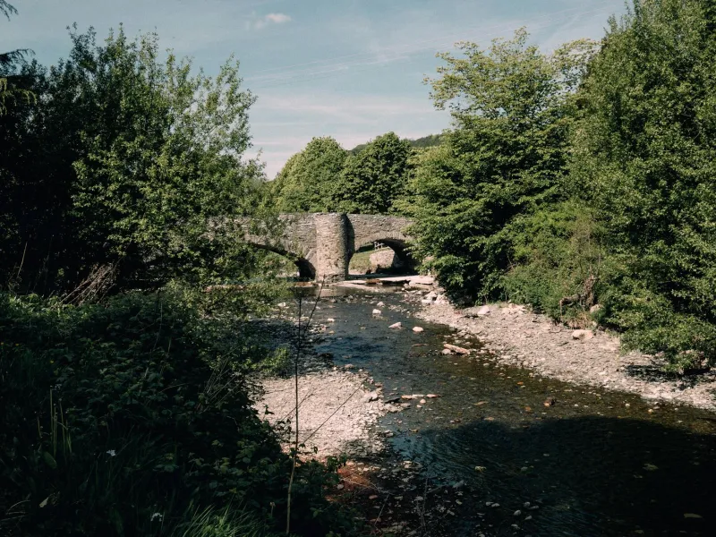
 Photo: Millbrook Bridge, via ocecontractingny.com
The trouble began with what seemed like a routine federal infrastructure project. In 1889, Congress allocated funds to build a bridge across Sugar Creek, connecting the growing town of Millbrook with the main county road system. It was exactly the kind of practical investment that helped rural America modernize during the late 19th century.
What nobody anticipated was that the surveying crew would work from a map where the cardinal directions had been accidentally swapped during printing.
The Map That Broke Geography
The survey error should have been caught immediately, but a perfect storm of bureaucratic assumptions allowed it to slip through multiple checkpoints. The federal survey team arrived from Washington with their misprinted maps, assuming local officials had verified the geographical information. Local officials, impressed by the federal team's credentials and detailed paperwork, assumed the maps were correct.
For three weeks, surveyors carefully measured distances, calculated angles, and marked construction points with mathematical precision. Every measurement was double-checked. Every calculation was verified. The only problem was that their reference point—magnetic north—was actually pointing toward magnetic south on their maps.
The result was a bridge design that would cross Sugar Creek at exactly the wrong location, connecting Millbrook not to the county road as intended, but to a sparsely populated hillside where the Miller family kept sheep.
Construction Proceeds Despite Reality
The construction crew that arrived from Chicago six weeks later noticed something odd about the bridge location, but they had learned not to question federal engineering decisions. If Washington wanted a bridge connecting a town to a sheep pasture, there must be a good reason.
Local residents watched with growing confusion as work progressed. The bridge was beautifully constructed—solid stone foundations, expertly fitted timber planking, and ironwork that would last decades. But it was pointing toward the Miller farm instead of toward the road everyone actually wanted to reach.
Several townspeople approached the construction foreman with concerns, but he politely explained that the engineering specifications came directly from federal surveyors and couldn't be altered without written authorization from Washington. Such authorization would require months of correspondence and potentially void the construction contract.
Work continued through the summer and fall of 1889, producing what was arguably the finest bridge in three counties—in completely the wrong location.
The Moment of Truth
The error became undeniable during the bridge's official inspection in November 1889. Federal engineer Thomas Morrison arrived from Indianapolis expecting to approve a standard creek crossing that would connect Millbrook to the county road network. Instead, he found a magnificent bridge that connected Millbrook to approximately 400 acres of sheep pasture and woodland.
 Photo: Thomas Morrison, via images.serp.media
Morrison's inspection report, preserved in the National Archives, captures his bewilderment with bureaucratic understatement: "The completed structure appears to have been constructed facing an unintended direction due to survey complications. While the bridge meets all federal construction standards, its practical utility may be limited by geographical considerations."
Translation: They built a perfect bridge pointing exactly where nobody wanted to go.
The Economics of Admitting Mistakes
Facing a choice between tearing down a $50,000 bridge (roughly $1.5 million in today's money) or finding a way to make it useful, local officials chose pragmatism over pride. Rather than admit the embarrassing mistake to federal authorities, they quietly decided to work around it.
The solution was elegantly simple: build a road to meet the bridge where it actually stood. If the bridge couldn't connect Millbrook to the county road, then they'd create a new route that made the bridge's location logical.
Over the following year, local work crews carved a winding road through the Miller property, across the hillside, and eventually back to the main county road system. The route was longer and more circuitous than originally planned, but it transformed the misplaced bridge from a costly mistake into a functional piece of infrastructure.
The Miller Family's Unexpected Windfall
The biggest winners in this geographical comedy were the Miller family, whose sheep pasture suddenly became a crucial transportation hub. The county paid them handsomely for the right-of-way across their property and for the inconvenience of having a major bridge terminus in their backyard.
Within five years, the Millers had opened a small general store at the bridge approach, taking advantage of the steady traffic that now passed through their former pasture. By 1900, they'd added a blacksmith shop and a small inn for travelers. What had been isolated farmland became a minor commercial center, all because someone had printed a map backward.
The Miller family operated businesses at the bridge site for three generations, finally selling to the county in 1967 when automobile traffic made their roadside enterprises obsolete.
Still Standing, Still Serving
Today, the Millbrook Bridge carries local traffic across Sugar Creek just as it has for more than 130 years. The original stone foundations remain solid, though the timber decking has been replaced several times and the approaches have been modernized for contemporary vehicles.
Most drivers who cross the bridge daily have no idea they're traveling over one of America's most expensive directional errors. The winding approach road, now called Miller's Route in honor of the family whose sheep pasture became a transportation corridor, seems like a natural part of the local geography.
The bridge appears on county maps, state highway databases, and GPS systems with no indication of its peculiar origin story. It's a perfectly normal piece of infrastructure that happens to exist because someone once printed a map with north and south reversed, and nobody wanted to admit the mistake.
In an age of billion-dollar infrastructure projects and complex environmental impact studies, there's something refreshingly practical about a community that simply built a road to match their misplaced bridge. Sometimes the most efficient solution to a planning disaster is just to make the disaster work.